Hydroportal - acquiring information about the waters has never been easier!
2 czerwca 2021 r.
Would you like to purchase a property and check if it will not be flooded? Would you like to know for sure which unit of Polish Waters to send the document to? Are you interested to know in which body of water the plot is located? Would you like to know what are the limitations in achieving environment protection goals for your investment? The answers to the above questions - and not only - are available on Hydroportal. Check how to search for and use the information resources provided by the National Water Management Authority.
Hydroportal is a public mapping portal gathering information on generally understood water management for the territory of Poland, involving e.g. flood risk, the hydrographic network, water facilities and structures or water management plans, where we can find information on surface and groundwater bodies. Collecting all data related to water management in a single, generally accessible place allows the users to quickly obtain comprehensive data about hydrography, about the terms and conditions for using water resources, as well as about threats and risks related to flooding. Launching Hydroportal allowed for direct access to the above data from anywhere in the world, at any time and for all interested parties, starting from ordinary citizens, through representatives of offices, scientific institutions, planning studios, non-governmental organizations, to commercial companies implementing projects related to hydrology and environmental protection.
What data can be found on Hydroportal?
For easier and faster searching for the necessary information, the data on the Hydroportal has been grouped into several thematic modules, with access to the following data sets:
- Preliminary Flood Risk Assessment (WORP)
- Flood hazard maps (MZP)
- Flood risk maps (MRP)
- Water management plans
- Flood risk management plans,
- The National Program for Municipal Wastewater Treatment.
- Water Management Information System (SIGW)
- MZP and MRP maps in pdf format
The portal is successively supplied with new sets of data, e.g. with a plan to counteract the effects of drought. Information about the recently published data will be published on the National Water Management Facility's website.
What functionalities does Hydroportal offer?
The interface of the Hydroportal is user-friendly and does not differ significantly from map services provided by other institutions. The core functionalities include identification of objects, preparation of own map compositions and connection of WMS services, length measurements, area calculation, and even advanced sketching options. The website displays cursor coordinates in PUWG 1992, PUWG 2000 and WGS 84 systems. Hydroportal has been equipped with search tools according to place names, hydrographic and hydrotechnical objects and units of the National Water Management Facility. There are special tools for this in the "Search" tab. The content of this tab differs depending on the module currently used by the user. After selecting a proper tool and entering the necessary information, the user can search for objects that meet the given criteria. A very useful option is also searching by specific plots of land. It is enough to provide selected parameters of the plot, e.g. voivodship, poviate, commune, precinct, number and we can quickly obtain information about the real estate we are interested in.
Hydroportal for the citizen
Because it is easy to operate and has a wide range of different functionalities, Hydroportal is a practical application for each of us. If a user wishes to submit an application to the management of a certain basin of the National Water Management Facility, and is in doubt as to which unit - territorially competent - our case should be addressed to, the user can quickly check it on the Hydroportal using the thematic layer "Borders of National Water Management Facility's units" and the identification tool. After zooming in on the map view to the area of interest, turn on the layer with unit boundaries, it is necessary to select the identification tool and click on the area of interest on the map - a new window will appear with the geographically competent unitis for handling our case.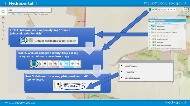
Do you live near a river and want to know if your immediate neighborhood is at risk of flooding? See how easy it is! From the list of available modules, select "Flood hazard maps", and in the map content window, activate layers with selected water depths. Then, using the search tool, the user may find their location and immediately see whether their neighborhood is exposed to the risk of flooding and to what height the water may reach in the event of flooding a given plot.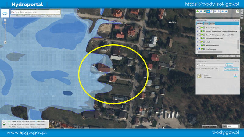
Hydroportal for the investor
If we are building a water facility or we intend to use water in a way that may have a negative impact on achieving the environmental objectives set for water resources, we should check whether a water body has been designated in the area of the planned operation and what possible restrictions apply to us. This information can be found in the Water management plans module. After loading the map, just zoom the view to the area of interest. Then, using the identification tool, you can easily check the catchment area of which the body of water is located and you can obtain detailed information for the indicated planning unit.
After confirming that there is a water body in the area of interest and we want to learn more about it, we can use the "WB Search" tool. After a specific parameter, such as a name, is provided, the tool finds a specific object. When the water body you are interested in appears in the search results, click on the field with its name. Then the map view will be brought closer to the searched object and an additional window will pop up with detailed information, including a link to the data sheet of this JCW. More information can be found in uniform water body search instructions.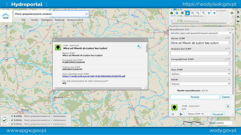
Hydroportal as a tool supporting the implementation of industry projects
Design work often requires the analysis of data provided by various institutions. With the "Add WMS / WMTS" tool, it is possible to connect external map services to the map view in the WMS format (international standard for sharing spatial data in the raster form) and WMTS (international standard for sharing spatial data in the form of raster, predefined map fragments, so-called tiles) . In addition, the Hydroportal lists the addresses of the WMS / WMTS services of the collections provided by PGW Woda Polskie, which can be used in any GIS software. Up-to-date information about the network services available so far can be found in the "Add WMS / WMTS" tab.
The key to making effective strategic decisions is a thorough analysis of the relationships between individual objects. The "Advanced Search" tool has been made available on the Hydroportal, which allowes for carrying out analyses both on the basis of attributes and through spatial queries. Remember that searching for objects takes place only within the active layer - this information is available in the tool window and on the information bar at the bottom of the map window. You can activate any layer and select objects on it at any time. The ability to export selected objects, for example to a file in .shp format, allows you to process them further in the desktop software. It is also possible to save the current user session and continue your work in the following days directly in the application.
Prepare your own map and share the results of your work!
After the analyzes are completed, you can prepare an overview map or share its current view with other users. Using the "Print" tool, we will not only display a map ready to be printed, but also adjust its appearance to our preferences. Modification of advanced settings allows, among others changing the paper size, orientation, quality and type of printout - e.g. directly to a printer or exporting to a PDF file, as well as adding additional map elements such as legends, line scale, north arrows, corner coordinates, etc.
The "Link to the application" tool allows you to generate a link (URL) to the displayed map composition, that is the current extent of the map, including enabled and disabled thematic layers. The copied link can be forwarded to another user by any means of communication, e.g. by e-mail or shared on social media.
In the article, we presented selected examples of the use of information and tools available on Hydroportal. More useful functions with detailed descriptions can be found in our instructions. The application is constantly being developed and soon new data sets and functionalities will appear in it. Regularly visit Hydroportal and the website of the National Water Management Facility and stay up to date!
Show us how you use Hydroportal in your daily work or during the implementation of projects at the university - inspire other users and send us your idea to the following address: hydroportal@wody.gov.pl.
Authors: Gabriela Kuc and Jolanta Szablewska-Wiraszka.
Rest news
- Polish Waters Authority have obtained a grant from the European Union to develop the projects for the third update of drafts of the 3rd Update of River Basin Management Plans
- There it is! The first plug from The National Water Management Authority is ready for download.
- World Water Day 2022 under the slogan "Making the invisible visible"
- The validity period of the 2016 water management plans was extended until 22.12.2022.
- From plans to action - what awaits the water management in Poland?
- We will not improve the status of water without specific actions